WWU078 - Severe Weather Tuesday (5/20)
- Weather Weenie
- May 19, 2025
- 0 min read
 |
Good evening Weenies. This is my first report made in the website.
We may have some severe weather tomorrow.
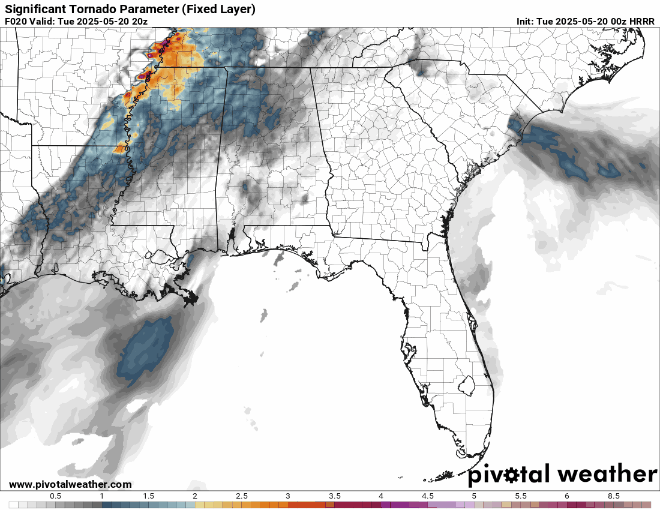
WWU078 Hey, tornadoes are on the table now May 20th Outlook Weenies, I'm not sure if my last report reached everyone I intended it to, that's why we're doing this now. I'm not quite sure how these goofy reports turned into this, but I'm glad they have. This is fun. Here is the updated categorical threat graphic from the NWS as of around noon today. We are now included in the enhanced risk (3/5) (Remember - this weekend was a 1/5)  Let's look at what our local office has to say:  We have some timing now, and surprise! It's another overnighter. As we have (very) recently learned, strong winds can certainly be a real issue, and that will likely be our biggest risk for this event, although a tornado or two isn't out of the question. Let's Break it DownWelcome to the Day 2 Outlooks - where we have specific tornado, hail, and wind threats broken down. Below is the tornado threat. This makes the report because that 10% Significant hatched area is a little closer to us than it needs to be. (Reminder - hatched areas are significant tornadoes, which is EF2+ or Long-Track)  Here's the most probable outcome - just a lot of strong winds. (Look at that 45%!!!) Since the ground is already saturated, and all of our trees are already barely hanging on from this weekend, I bet we have some issues here. "What doesn't kill you makes you stronger" does not apply in this case.  Quick scan of the forecasted reflectivity from the HRRR and NAM 3km, and uh, they agree. This will likely be a line of storms that roll through.   Are you ready? WEENIEINGSI'm not sure if you remember the Significant Tornado Parameter from last night the same way I do, but these sure are a little spicier.
Again, enjoy the HRRR and NAM 3km from the same timeframe as that line of storms.
  Does this mean certain death and destruction? No. It does mean that we should have plenty of storm soup outside for it to... 1. Feel super clammy and stormy 2. Make me run around outside saying "DOESN'T IT FEEL CONVECTIVE?" 3. Fuel some substantially strong storms whether they decide to spin or not Let's take a minute and look at some stuff everyone has probably seen before, temperature and humidity. These are the ingredients that make it feel stormy. As you can see, warm and clammy. Up to the mid 80s and very high humidity/dewpoints.   I like showing the relative humidity for this one since you can see where the line of storms is - and that it's summoning its own humidity to work with ahead of itself. Pretty cool.
This will probably be my last full update before the storms. I may post on Slack for my SPOC Weenies.
If there are any other large changes to the forecast I'll communicate it to everyone.
One more very important note: The NOAA Weather Radio for the Birmingham area will be DOWN for this event. They are upgrading it and the timing is just bad. Make sure you have emergency alerts activated on your phone and/or other ways to get alerts. Make sure you have something that will wake you up in the event of a strong storm. Be safe and stay Weather Weenie Aware KR4BZF I've moved resources to a page here - I'm working on adding all of them. The most important ones are already on there - check them out! During the event make sure you keep tabs on what is going on with your favorite local weatherman.
Whether that's James or Wes. I don't care. I hope you have enjoyed today's weather weenie update. Stay Weather Weenie Aware. Kaila - Weather Weenie - KR4BZF |


Comments