WWU077 - Respect the Green
- Weather Weenie
- May 19, 2025
- 5 min read

Updated: May 24, 2025
 |
Good evening Weenies. What was all that about this weekend? I didn't mean to leave you data-less :( WWU077 Respect the Green (Also Tuesday may give us issues) May 17th-18th Recap and May 20th Outlook Weenies, there is a lot to unpack for this report. First I want to cover what we know about Tuesday, then I'll explain what happened to us this weekend. It's good to be back, Weenies. Also, a very special welcome to our new Weenies. Tuesday (5/20)  Weenies, we've missed A LOT of the severe weather this season - which is a good thing. Tuesday is our first substantial (Weenie Report Worthy) event since the high risk on March 25th, so "It's Been a While" 1(Staind 0:17). It seems, so far, that our main threat for Tuesday will be strong winds and hail in the afternoon/evening. Let's check out what our local office has to say and look at the overall setup. At some point in the near future, I'd like to do a quick weenie recap of this severe season. There were some very impressive storms and I'd love to share my love of that with you guys.  No official timings are released yet, but we're near enough for our close-range models (NAM 3km and HRRR - the whole storm fit in the last model run and it was beautiful) to work for us. We can already see that it's trying to be spicy, and has the possibility of intensifying in the next few days. Quick BreakdownHere is the predicted reflectivity (or just normal radar view) for Tuesday. We can learn a few things from this. First, it'll probably be a sort of line that forms, AKA our friend the Quasi Linear Convective System (QLCS). This means strong winds and fairly organized storms. A big ol' however, see that little line behind that first one? That's the actual front. Sooooo the first line that forms has LOTS of juice available to it - hence the interest in Tuesday. Storms before front = unlimited energy, the front is the bulldozer that pushes all of the storm soup away. 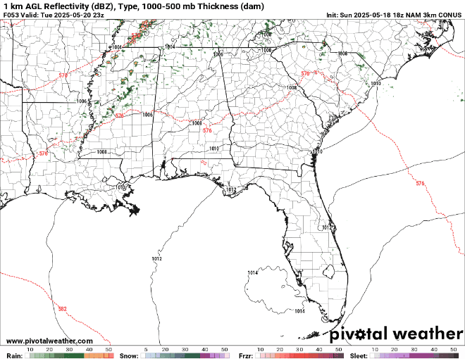 Let's jump right into where we always seem to end up - the Significant Tornado Parameter. Remember how tornadoes aren't specified as a threat yet? Yeah. So. They technically aren't. "But Kaila, that looks like tornadoes" Yes. Because the same things that make hail and winds are the same things that make tornadoes. This is of particular interest because it starts to fall apart at the end of the run, so we aren't quite sure what it will decide to do yet. (Reminder - the end of the model run is notoriously random, just like any other time series regression calculation too far out. Do you know what 6 months away will look like? I don't. Honestly, neither does math.)  So what do we have to work off of? We know it can be spicy, that's why we're looking. Below is the fun wormy chart, CAPE and Hodographs (Convective Available Potential Energy and wind speed/direction with atmospheric height) So we have some spin and we have juice, that's the main reason we care.  This is an evolving situation, and we don't know all the details yet, but I wanted it on everyone's radar - especially after the last two days. WHAT HAPPENED THIS WEEKEND?How about that transition? This weekend wasn't supposed to be this violent. It was supposed to be windy, and maybe some hail. Hey, remember how I tell you to not care about the threat level or color, and that it's the fact that there is a threat at all that you should care about? Yeah. We were just happy little green this weekend. Respect the Green, Weenies. Respect it. Here's the NWS BHM outlooks for this weekend. Same general message for both days. Some winds, some hail.   So what's the message for you guys? I want you to care about the yellow and orange for Tuesday. I want you to care because it isn't red or pink. As important - I did not intentionally leave all of my Weenies without information for the weekend - this caught all of us off guard. This is a good case study to show that as good as the data and models can be, the atmosphere will still do what it wants to do - and we cannot control that. I hope none of you guys got any damage, and I hope that no one else had to spend your weekend removing fallen trees. If you also had to, I have Advil at my desk for my SPOC Weenies. Again, welcome to my new Weenies. Let me know your thoughts or if there is any other information you would like me to include in these. Little known fact for my existing Weenies, you can respond to this email, in fact - it's encouraged. ------------------------------------------------------------------------------------------ Quick Personal Weenie Updates - Guess what? I'm working with the Alabama Emergency Response Team (ALERT) in conjunction with the National Weather Service in Birmingham. I'm a ham radio operator reporting local conditions to the weather service. We also rotate out as a team to operate the ham radios at the weather service. This has also led to me working closely with the city of Trussville. No, I don't chase tornadoes. Not yet. Seriously though, I'm very thankful for everyone that has helped me with this so far. As you can guess, it's literally a dream come true for me, hence this picture...  ------------------------------------------------------------------------------------------ Be safe and stay Weather Weenie Aware KR4BZF You know I can't leave you without resources Local Weather Sources: X - (or Twitter - my favorite for updates because it is the fastest): @NWSBirmingham - Local office, shares all info @NWSTornado - Shares all tornado information @NWSSPC - Storm prediction center, shares major updates Websites: NWS Birmingham - Local - Updates with less frequency, but has good info NWS Day 1 Convective Outlook - Updates at 1am, 8am, 11:30am, 3pm, and 8pm NWS Mesoscale Discussions - Active during events Want to be even nerdier? - Pivotal Weather Thanks to one of my weenies, have this too - Tornado HQ Hey - a new weenie resource that's tons of fun. At least for me. NIU Dynamical Severe Weather Forecasts - Long Range Outlooks over the CONUS Also, keep tabs on what is going on with your favorite local weatherman. Whether that's James or Wes. I don't care. Works Cited: 1 Staind. "It's Been Awhile." Break The Cycle. Flip Records & Elektra Entertainment Group Inc, 2002. CD. I hope you have enjoyed today's weather weenie update. Stay Weather Weenie Aware. I wanted to say Green Weenies and Ham in this report. But I couldn't make it fit. So you get it here. Kaila - Weather Weenie - KR4BZF |


Comments